EUROVIA CZ cuts surveying time from days to 30 minutes with three-month ROI
The team shifted from traditional geodetic surveys, which used to require several people and days of work, to drone-based photogrammetry that captures each area in just 30 minutes. Their investment in drones and AVAG processing paid for itself within three months while delivering results accurate enough for invoicing and ready to be certified by an authorized surveyor when needed.
Challenges
Traditional surveying required multiple workers and took days to complete
Slow data processing with limited ability to share results across teams
Difficulty comparing project plans against real-world site conditions
Need for legally valid survey data for invoicing and official documentation
Solutions
Deploying drones for weekly site monitoring (30 minutes per area, one pilot)
Implementing AVAG cloud platform for fast processing with multi-user access
Enabling design overlay on 3D models to compare plans with reality
Used AVAG’s certified method producing legally valid outputs
Results
Surveying reduced from days to 30 minutes; 100,000 CZK investment paid back in three months
Next-day results with 1,121 GB processed across 169 data layers
Teams visualize designs on 3D models with maps and current photos
AVAG outputs used for invoicing and official documentation

The investment decision that paid off in 90 days
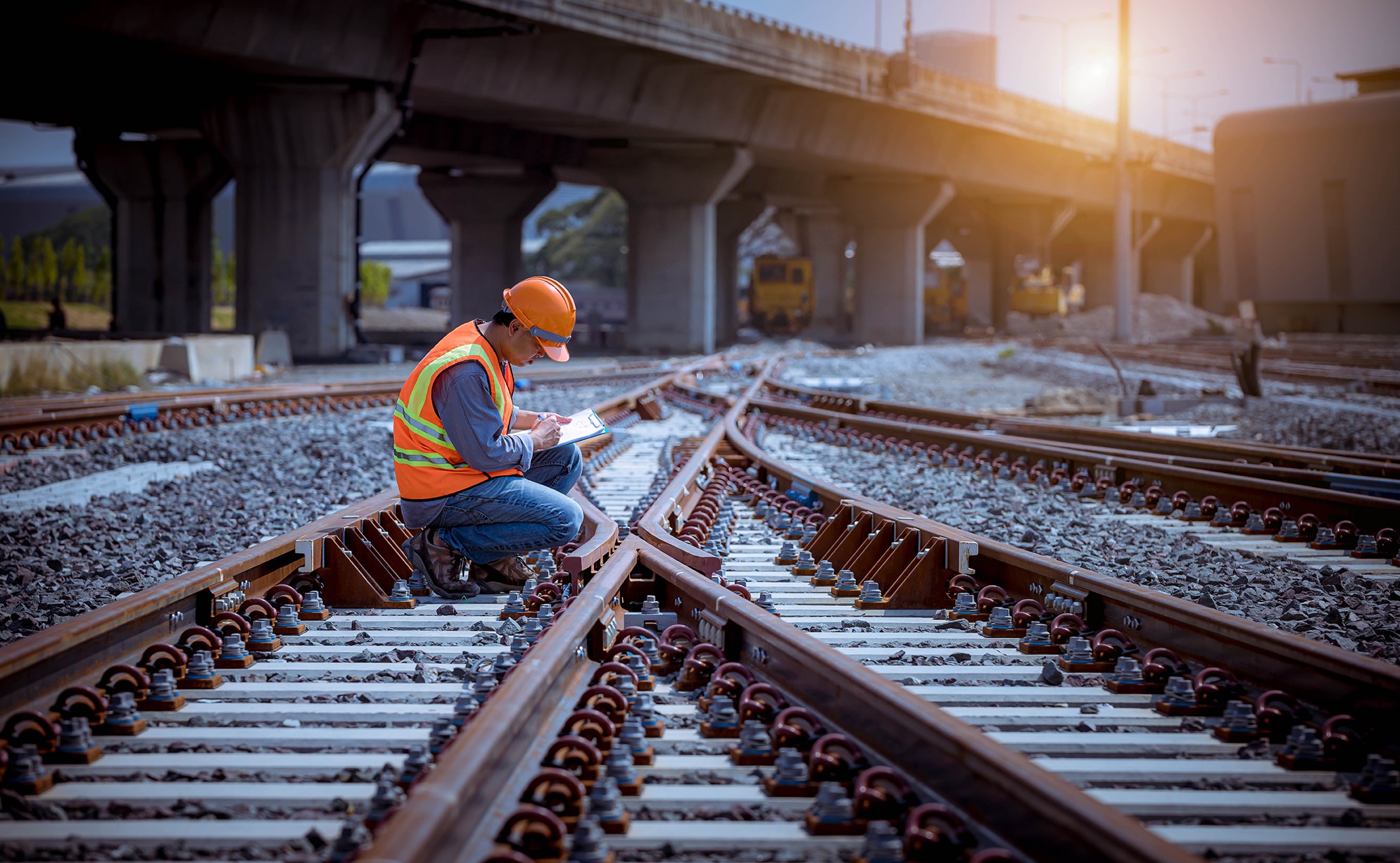
The modernization of the Kladno-Ostrovec railway line represents a significant infrastructure upgrade, expanding a single-track line to double-track with new platforms, underpasses, bridges, and grade-separated crossings replacing the busiest level crossings. Modern signaling systems and completely new track structure ensure faster, more ecological, efficient, and safer transport.
For a project of this scale, traditional surveying methods presented significant challenges in terms of time, personnel requirements, and coordination.
“We started exploring drones for construction sites in 2019 to reduce the workload for surveyors measuring earthworks. Our colleagues at AirView showed us not just the drones themselves, but, more importantly, what we could do with the data they captured,” says Tomas Pechr, Project Director at EUROVIA CZ.
The decision to pilot drones required buy-in from leadership. The team approached their superior and explained how drones would accelerate processes on site and bring savings in geodetic work. The business case proved solid: after three months of using drones, the team achieved both financial savings and faster data processing. In addition, the initial investment of approximately €4,000 paid for itself completely during those first three months.
Compare drone surveying costs to traditional methods
Drone + AVAG
Flying time
30 min
Processing time
9 hours
Approx cost.
€125
— vs —
Human workers
Mapping time
3 days
Processing time
7 days
Approx cost.
€1,000+
From days to 30 minutes: The new workflow
Having validated the approach on earlier projects, EUROVIA CZ deployed drones and AVAG as standard, proven technology on the Kladno-Ostrovec railway modernization from the start.
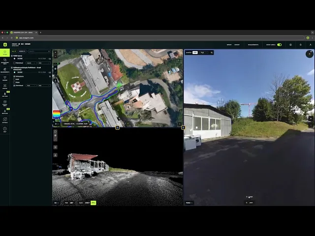
On this site, the construction manager flies the drone, and they survey the entire construction site once a week. One area takes approximately 30 minutes to capture. The construction manager uploads the images to AVAG’s cloud platform, which processes them to create 3D models and run calculations.
Technical workflow
Data volume:
1,121 GB processed across project
Processing time:
Approximately 9 hours
Frequency:
Weekly flights on average
Drone model:
Mavic 3E RTK
The original method required a surveyor and several assistants working for days. Drones made the entire process much simpler and faster.
“Processing data from one flight takes about 9 hours. We typically upload data to AVAG one day, it processes quickly, and we have results the next morning.”
Zdenek Bahensky
Construction Manager and Drone Pilot, EUROVIA CZ
Seeing the invisible: Project design meets reality
Drone photogrammetry opens up entirely new capabilities. Teams can overlay project plans onto the current surface captured by drones, comparing what designers planned with what’s actually on the ground.
"Drones start working before construction even begins. We first photograph the land where we’ll store materials and the areas where we'll build. A regular photo doesn't tell the whole story. With drones, we get the exact terrain shape and elevation of every point. On a construction site, this becomes a powerful tool for making decisions. We use it with everyone: contractors, utility companies, site supervisors, and within our own team," says Zdenek Bahensky.
Railway projects typically involve moving huge amounts of material for the track foundation and rails. The drone data provides essential calculations: volumes of any shape, cross-sections, elevation measurements accurate to 3 cm—all standard outputs. The 3D model clearly shows all excavations, cuts, and slope angles, and can even be used for automatic leveling of construction equipment.
Legal weight without the stamp: Certified accuracy
The precision of the drone data goes beyond internal planning. It’s accurate enough to use for billing clients and official documentation.
“AVAG delivers highly reliable results. When an authorized surveyor reviews the outputs and applies their stamp, the documents carry full legal weight,” explains Miroslav Staubr, CEO at AVAG Pro.
This means volume calculations, measurements, and other data derived from drone flights can support invoicing subcontractors and meeting regulatory requirements.
Widespread adoption and collaboration
A key advantage of the AVAG application is that a large number of people who are connected to a specific construction project can have access to it. This can include users not only from the construction company but also their suppliers, client representatives, designers, and other specialists.
“Initially I registered a certain skepticism toward using drones, especially regarding accuracy, but that very quickly disappeared after all users personally confirmed the usefulness of the outputs that the technology enables. Today, everyone on the construction site works with AVAG—all construction managers, the coordinator, and individual specialists, including employees of subcontractors. Data from drones is a far more comprehensive source of information than typical project documentation. Everyone sees the same information, which we can also share very easily with each other. This significantly simplifies any coordination,” says Zdenek Bahensky.
Scaling success across the organization
EUROVIA CZ now uses the lessons learned from the Kladno-Ostrovec project on other railway construction sites. By the end of 2024, the company had grown to 3 drones and 3 trained construction managers who pilot them.
AVAG highlights
1,121 GB of data processed
Comprehensive documentation across entire project lifecycle
169 data layers for calculations
Enabling detailed analysis and multiple calculation types
“Dozens of drone flights have created many data layers, providing detailed views of what’s actually happening on site. This helps teams evaluate situations faster and make better decisions about next steps. In AVAG, we combine the drone data with CAD drawings and inspection photos—including 360° images, high-resolution grids, and even mobile phone pictures. But from my perspective, the most valuable thing is how easily all this site data can be shared with everyone who needs it.”

Miroslav Staubr
CEO, AVAG Pro
Project details
Eurovia
Project name
Modernization of the Kladno - Kladno-Ostrovec line
Timeline
10/2022 – 12/2028
Railway line length
5.3 km
Number of revitalized stations and stops
3
Number of new platforms
7
Investor
Sprava zeleznic, statni organizace (Railway Administration, state organization)
Contractor
Spolecnost Kladno – EUROVIA CZ a.s., Strabag Rail a.s., Elektrizace zeleznic Praha a.s.
Application
Make decisions in hours instead of weeks
Turn drone data into action with AVAG. Capture, process, and visualize your site faster than ever.


