M-SILNICE modernizes earthwork documentation with drone surveying

M-SILNICE accelerates earthwork documentation with drone surveying

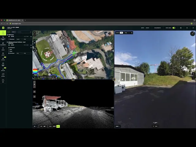
M-SILNICE introduced drone surveying and AVAG cloud processing from day one on the D35 Krelov–Slavonin highway project, replacing traditional geodetic methods with fast, on-site photogrammetry for earthwork documentation and volumetric calculations. Monthly (and on-demand) drone flights replace several days of manual surveying while giving construction managers the aerial overview needed for quick verification and accurate invoicing.

Industry

Highway infrastructure

Challenges

  • Hilly, undeveloped terrain requiring continuous earthwork monitoring

  • Regular progress reports with accurate volumetric data for subcontractor invoicing

  • Windy sections of the site complicating flight planning

  • Coordinating earthworks across a 3.2 km highway section with multiple structures

Solutions

  • Using a DJI Mavic 3 Enterprise RTK stored directly on-site for flexible, as-needed flights

  • Processing data in the AVAG cloud for automated calculations and progress documentation

  • Allowing construction managers to upload flight data themselves—no external survey crews

  • Combining drone outputs with selected traditional geodetic methods for full site coverage

  • Using a DJI Mavic 3 Enterprise RTK stored directly on-site for flexible, as-needed flights

  • Processing data in AVAG for automated calculations and progress documentation

  • Allowing construction managers to upload flight data themselves—no external survey crews

  • Combining drone outputs with selected traditional methods for full site coverage

Results

  • Monthly and event-based drone flights save multiple days of manual surveying

  • Approximately 20 GB of data generated per flight, scaled across 12 months of documentation

  • Centimeter-level spatial accuracy achieved through RTK + ground control points (GCPs)

  • On-site drone availability enables immediate data capture after key construction stages, keeping work moving without delays

Solving a major traffic bottleneck

Every day, 18,000 vehicles pass the Globus hypermarket near Olomouc, creating persistent congestion. The solution was to complete the western bypass connecting Olomouc to the D35 toward Mohelnice and the D46 toward Brno.

Before ground was broken, M-SILNICE began capturing drone images along the 3.2 km section."We’ve been using the drone since the very start. The first images were taken before we figuratively broke ground. I had experience with drone photogrammetry and AVAG from other projects, so this wasn’t new for us," says Michal Horak, Operations Manager Litovel at M-SILNICE.

The route passes through hilly, undeveloped land, with the most demanding stage—connecting the bypass to the D35—scheduled for 2025.

The construction manager flies the drone about once per month, or anytime a major layer or earthwork is finished. Flight data is uploaded immediately to AVAG, which automatically processes volumes for progress reports and invoicing.

The aerial view provides fast, reliable verification against plans, ensuring teams can confirm progress without delays.

Every day, 18,000 vehicles pass the Globus hypermarket near Olomouc, creating persistent congestion. The solution was to complete the western bypass connecting Olomouc to the D35 toward Mohelnice and the D46 toward Brno.

Before ground was broken, M-SILNICE began capturing drone images along the 3.2 km section. "We’ve been using the drone since the very start. The first images were taken before we figuratively broke ground. I had experience with drone photogrammetry and AVAG from other projects, so this wasn’t new for us, says Michal Horak, Operations Manager Litovel at M-SILNICE.

The route passes through hilly, undeveloped land, with the most demanding stage, which will connect the bypass to the D35, scheduled for 2025.

The construction manager flies the drone about once per month, or anytime a major layer or earthwork is finished. Flight data is uploaded immediately to AVAG, which automatically processes volumes for progress reports and invoicing.

The aerial view provides fast, reliable verification against plans, ensuring teams can confirm progress without delays.

Weather flexibility: Flights when the site allows

Keeping the drone on-site eliminates the need to schedule external survey teams and makes weather issues manageable.

Every day, 18,000 vehicles pass the Globus hypermarket near Olomouc, creating persistent congestion. The solution was to complete the western bypass connecting Olomouc to the D35 toward Mohelnice and the D46 toward Brno.

Before ground was broken, M-SILNICE began capturing drone images along the 3.2 km section. "We’ve been using the drone since the very start. The first images were taken before we figuratively broke ground. I had experience with drone photogrammetry and AVAG from other projects, so this wasn’t new for us, says Michal Horak, Operations Manager Litovel at M-SILNICE.

The route passes through hilly, undeveloped land, with the most demanding stage, which will connect the bypass to the D35, scheduled for 2025.

The construction manager flies the drone about once per month, or anytime a major layer or earthwork is finished. Flight data is uploaded immediately to AVAG, which automatically processes volumes for progress reports and invoicing.

The aerial view provides fast, reliable verification against plans, ensuring teams can confirm progress without delays.

“We have several windy spots where we’ve had to interrupt flights. But because the drone is always on the site, it’s no problem—we just fly the next day. When a stage is finished, we can capture the data in minutes and keep construction moving. AVAG isn’t affected by weather at all.”

Michal Horak

Operations Manager Litovel, M-SILNICE

Drone photogrammetry covers all earthworks and selected structural layers, while traditional geodetic tools are used for specialized measurements. This hybrid method ensures complete documentation without slowing the project.

AVAG and drone data deliver centimeter accuracy thanks to the combination of RTK and GCPs, with no limits on file sizes and near-instant initial processing.

Balanced approach: Drones + geodetic methods

Drone photogrammetry covers all earthworks and selected structural layers, while traditional geodetic tools are used for specialized measurements. This hybrid method ensures complete documentation without slowing the project.

AVAG and drone data deliver centimeter accuracy thanks to the combination of RTK and GCPs, with no limits on file sizes and near-instant initial processing.

Compare drone surveying costs to traditional methods

Drone + AVAG

Drone + AVAG

Drone + AVAG

Drone + AVAG

Flying time

1 km in 15–20 minutes (+ GCP setup)

Processing time

Seconds to initiate → outputs in hours

Approx cost.

Only AVAG processing

— vs —

Human workers

Human workers

Human workers

Human workers

Mapping time

2–4 days/month in the field

Processing time

Days for volumetric outputs

Approx cost.

10–15k CZK per day for a small crew

AVAG highlights

High-volume documentation: ~20 GB per flight over 12 months

Centimeter-level accuracy: RTK + GCP-based measurements

Unlimited data capacity: No file size limits

Instant calculations: Initial processing in seconds

“We’re pleased that AVAG is being used on all currently constructed highway sections in the Czech Republic. It’s not only about saving time and personnel because the system delivers centimeter-level accuracy and accepts unlimited data uploads.”

Marek Ruzek

CTO, AVAG Pro

Project details

Eurovia

Eurovia

Eurovia

Eurovia

Project name

D35 Krelov – Slavonin, Phase 2

Timeline

02/2024 – 12/2025

Railway line length

3,166 meters

Structures

3 bridges (222m total length), 1 grade-separated intersection, 1 roundabout, 437m noise barrier

Drone model

DJI Mavic 3 Enterprise RTK

Investor

RSD (The Road and Motorway Directorate of the Czech Republic)

Contractor

M-SILNICE a.s.

Application

Make decisions in hours instead of weeks

Turn drone data into action with AVAG. Capture, process, and visualize your site faster than ever.

Clients

What our clients say

Discover the success stories and testimonials from our satisfied clients who have transformed their workflow with AVAG.

Clients

What our clients say

Discover the success stories and testimonials from our satisfied clients who have transformed their workflow with AVAG.

Clients

What our clients say

Discover the success stories and testimonials from our satisfied clients who have transformed their workflow with AVAG.

Clients

What our clients say

Discover the success stories and testimonials from our satisfied clients who have transformed their workflow with AVAG.