How STRABAG measures every detail across 10.5 km of highway
STRABAG uses drones for monthly site measurements, turning 3,500+ photos into billing documents within hours. After a successful deployment of AVAG on the D35 Litomysl–Janov highway, the tool is set to become the standard across the entire STRABAG Group in 2026.

Challenges
Other tools could not handle 10.5 km of data smoothly, causing slow and frustrating work
Monthly billing cycles required fast turnaround with no tolerance for delays
Difficulty comparing project plans against real-world site conditions
Solutions
Processing all drone data in the AVAG cloud platform
Seamless workflow from data upload to multi-user analysis in AVAG
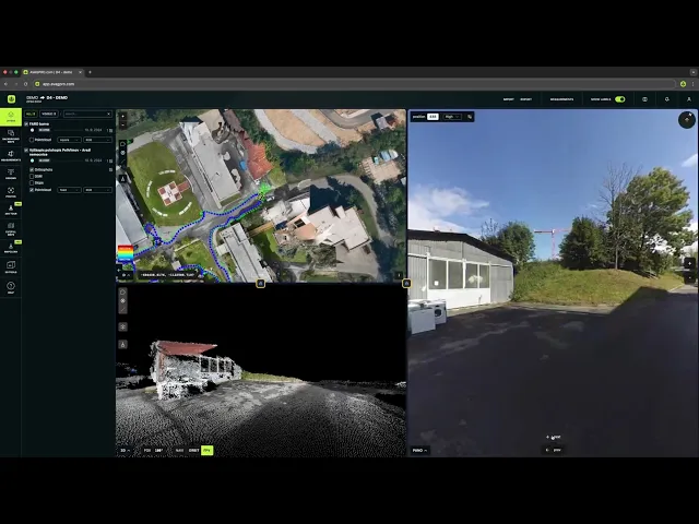
The multi-window feature enables easy side-by-side comparison of design plans and real site conditions in 2D and 3D
Results
Reliable processing of 3,500-5,000 photos per flight in 9 hours
Turning drone data into invoice-ready results in a matter of hours
Faster planning and fewer site visits using current, visual site data

When 10.5 kilometers breaks your software
The D35 Litomysl-Janov highway project presented STRABAG with a problem their existing tools couldn’t solve: How do you accurately measure and invoice earthworks across 10.5 kilometers of active construction every single month?
STRABAG had been using drones for five years, but when they tested multiple software platforms for D35, they all hit the same wall: none could keep up with the sheer scale of data from a 10.5-kilometer highway project, making work slow and frustrating.
“We had tried other tools, but the main difference is that AVAG can encompass the entire construction site. Other tools simply cannot. When we tried to work with 10.5 km of data, they couldn’t handle it,” says Tomas Hladina, Head of Construction Digitalization at STRABAG.
The company needed more than just processing power. They needed fast turnaround for monthly billing cycles, seamless integration with their BIM workflows, and outputs that would satisfy the strict requirements of the Czech Road and Motorway Directorate (RSD) for official invoicing.
Compare drone surveying costs to traditional methods
Drone + AVAG
Flying time
1-2 days
Processing time
9 hours
Approx cost.
€125
— vs —
Human workers
Mapping time
Several days or a rough estimate
Processing time
Several days or a rough estimate
Approx cost.
€1,000+
Testing a solution that could scale
STRABAG decided to test the AVAG platform on D35. With five years of drone experience and their own fleet of pilots, the team needed a processing platform that could keep pace with their operation. The scale of the challenge was clear from the start: regular flights capturing 3,500 to 5,000 photos, generating massive datasets including point clouds, DSMs, slope models, and orthophotos under tight deadlines tied to monthly billing cycles.
“We don’t have time to play around and wait. With AVAG, we never wait,” says Ondrej Kutilek, BIM Modeler at STRABAG.
The proof-of-concept trial included regular evaluations, and, at the end, STRABAG CZ quickly followed up by purchasing an additional license to process D35 data. In 2026, AVAG is set to become the standard processing platform for the entire STRABAG Group.
Technical workflow
Data volume:
3,300–5,000 photos per flight (6–9 MB each)
Outputs:
9.4 GB orthophoto, 1.3 GB DSM, 10.6 GB point cloud
Processing time:
Approximately 9 hours
Frequency:
Monthly flights
Drone model:
Matrice 4E RTK
One seamless workflow
The process starts on site, where a BIM coordinator captures the entire construction area on demand using drones. In summer, a full site can be captured in a single day; even in winter conditions, data collection is typically completed within two days.

When the flight is completed, STRABAG securely uploads the data to AVAG. An initial system check runs automatically, then a photogrammetry expert from AVAG reviews the photos and GCPs to ensure everything is correct. The data is then processed manually with care and oversight before undergoing further automated processing to generate orthophotos, DSM/DEM, and point clouds.
Once ready, AVAG notifies STRABAG that the new data is available. The entire workflow takes around 9 hours, combining hardware performance, expert review, and AVAG’s platform to ensure the data is 100% reliable.
Within 24 hours, surveyors review the outputs and export multi-protocol reports, a feature AVAG specifically developed in response to STRABAG’s needs. These reports include all calculated volumes and serve as ready-to-use attachments for STRABAG’s technical submissions to RSD (the project investor).
A construction manager then works directly in AVAG to define areas of interest, draw polygons for stockpiles and excavations, and instantly compares current site conditions with design models or previous months. This provides clear, visual proof of progress and removes ambiguity from earthworks reporting.
Finally, a project engineer reviews and certifies the calculation protocol. This certified output becomes the official document accepted by RSD, enabling monthly invoicing of 80% of earthworks based on objective, drone-derived measurements. The remaining 20% is reconciled at project completion.
“For us as professionals, there’s no debate. Drones combined with AVAG are the most reliable way to measure earthwork volumes. It’s as obvious as the sun rising in the morning.”

Tomas Hladina
Head of Construction Digitalization, STRABAG
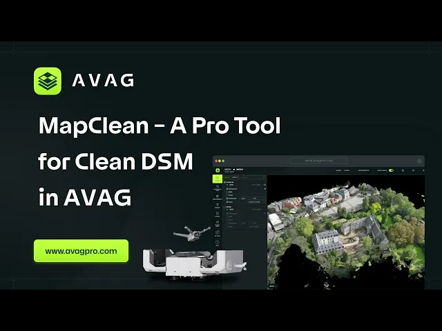
Customer-driven innovation: MapClean
During early deployments, STRABAG highlighted the need for an efficient way to clean DSM data before running volume calculations. In their previous tool, they relied on a dedicated cleanup feature to remove machinery and temporary structures.
When transitioning to AVAG, this capability was missing. STRABAG raised the requirement, and AVAG responded by developing MapClean, a dedicated DSM cleanup function, bringing this essential workflow into the platform. MapClean is now used on every flight to ensure accurate volume calculations.
Planning without stepping on site
What began as an invoicing solution quickly evolved into a planning tool. While monthly invoicing drove the initial adoption, STRABAG discovered that AVAG transformed how their entire team plans and coordinates work.
As confidence in the data grew, the platform became a shared environment where multiple roles could collaborate, test scenarios, and make decisions based on current site conditions, not assumptions.
“We used the previous tool only for invoicing, rarely for anything else. But in AVAG, multiple people use the map. For example, when we need to propose a location for drilling equipment—something not in the original project—we can click through the environment, we know all the elevations and can plan accordingly.”

Ondrej Kutilek
BIM Modeler, STRABAG
What once required multiple site visits, drawing revisions, and survey handoffs is now resolved directly in a single 3D environment. Instead of relying on static documentation, teams plan against the latest conditions, reducing delays and coordination overhead.
Managing mountains of surplus material
The D35 project faces a significant challenge: massive surplus material requiring temporary storage across multiple depot sites.
“This construction site deals with a large surplus of material, where we’re managing the storage of excess material. AVAG helps us tremendously in communicating with the construction site through those regular current flights,” says Hladina.
When the site needs to transport material to a depot, the workflow is straightforward:
The depot area is already captured in drone flights.
Team creates a 3D model of the depot in AVAG.
They calculate storage capacity and current fill percentage.
They can plan material movements with precise volume data.
This capability alone has saved countless hours of manual surveying and prevented costly miscalculations in material handling.
Seeing the project the way teams actually work
On a complex highway project like D35, decisions are rarely made in only one dimension. Designers think in plans, site teams think in terrain, and managers need both views at once. One of the reasons AVAG quickly became central to daily work at STRABAG is its ability to support all of these perspectives simultaneously.
With AVAG’s multi-window feature, teams can view 2D and 3D data side by side, a capability STRABAG hadn’t seen in any other platform.
“The benefit is the screen split between 2D and 3D views. We haven’t seen this kind of split in any other tool before,” notes Tomas Hladina.
This combined view means teams no longer have to translate between drawings and reality. Instead, they see exactly how design intent aligns with current site conditions, in real time. In practice, this allows STRABAG teams to:
Open any CAD files in 2D, without the compatibility issues experienced in previous tools
Overlay design layers directly onto the current 3D terrain model
Instantly switch between the previous flight, the current month’s survey, and design models
Review cross-sections to confirm excavation depth and construction progress
For a highway project with complex layered construction, being able to visualize “where we are” in both 2D plan view and 3D reality simultaneously eliminates confusion and speeds decision-making.
Proving it to the regulators: Every stone vs. every 20 meters
STRABAG had to convince RSD inspectors that 3D drone methods could match traditional surveying accuracy. The validation test was simple: RSD’s surveyors created control cross-sections using traditional methods every 20 meters along the highway. They generated a surface model from these measurements and uploaded it to AVAG to compare with the drone flight data.

STRABAG had to convince RSD inspectors that 3D drone methods could match traditional surveying accuracy. The validation test was simple: RSD’s surveyors created control cross-sections using traditional methods every 20 meters along the highway. They generated a surface model from these measurements and uploaded it to AVAG to compare with the drone flight data.
"It was beautiful to see how they matched to within a few centimeters. Meanwhile, the surveyors had measurements every 20 meters. We had every single stone," recalls Kutilek.
The comparison showed not only the accuracy of the drone-based method, but also its superior data density, capturing continuous, high-resolution detail across the entire project area rather than isolated measurement points.
Getting everyone on board—intuitively
When implementing new technology across a large construction site with multiple contractors, user adoption can make or break success.
“Training both the construction site and colleagues went very intuitively. User-friendly environment, good collaboration with AVAG. We were used to certain output protocols, and AVAG helped us by creating a tailored solution,” says Hladina.
The team specifically mentions that they’ve had “no user problems” and that “it’s not difficult to get into it.”
For a technology affecting many members of the team—from pilots to certified engineers—this ease of adoption was critical to achieving the fast turnaround times required for monthly invoicing.
After a year of collaboration and continuous refinement of the D35 workflow, AVAG is set to become the corporate-wide tool for the STRABAG Group in 2026.
AVAG highlights
3,500-5,000 photos per flight across the 10.5 km project
49 data layers including terrain models, orthophotos, and custom calculation zones
Fast processing – from flight to invoice-ready protocols in under 24 hours
80% drone-based invoicing – official RSD-approved methodology for monthly billing
“What I like most about the D35 project with STRABAG is how it evolved. They started using AVAG for invoicing, but it quickly became a shared platform for collaboration, planning, and decision-making across the site. Their move toward a group-wide rollout is the strongest validation we could ask for.”

Miroslav Staubr
CEO, AVAG Pro
Project details
STRABAG
Project name
D35 Litomysl - Janov highway construction
Timeline
02/2025 – summer 2027
Highway length
10.5 km
Investor
Road and Motorway Directorate (RSD), Czech Republic
Contractor
STRABAG (STRABAG Silnice a.s. & FIRESTA-Fiser)
Application
Make decisions in hours instead of weeks
Turn drone data into action with AVAG. Capture, process, and visualize your site faster than ever.