Tracking 32 km of progress in hours instead of weeks
Via Salis transformed documentation and surveying on the D4 highway construction, moving from traditional geodetic methods that could take weeks to drone-based photogrammetry with AVAG. The investment in drones and AVAG processing delivered precise volumetric calculations for invoicing while creating a collaborative platform for contractors, subcontractors, and project managers across the 32 km construction site, including multiple sections, bridges, tunnels, and other structures.

Challenges
Traditional surveying required multiple geodetic teams and would take weeks to cover the entire site
Need for precise volumetric calculations to support invoicing (2,127,000 m³ excavated, 315,000 m³ new soil delivered)
Difficulty coordinating data access across contractors, subcontractors, and management teams
Limited ability to compare real-time progress against project plans across the extensive site
Solutions
Deploying drones for monthly site monitoring across the full 32 km project
Implementing AVAG for processing and multi-user access across all project stakeholders
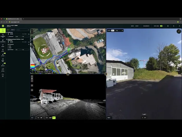
Enabling multi-layer data visualization combining orthophotos, 3D models, point clouds, and 360° panoramic photos
Using AVAG’s calculation methods for volumetric outputs supporting invoicing
Comparing drone data with design 3D models for machine guidance and construction verification
Results
Surveying reduced from weeks to a single day per 17 km segment
Complete site documentation including orthophotos, 3D models, point clouds, and 360° panoramic photos
Construction managers, project managers, and subcontractor teams access the same real-time data
AVAG calculations used directly for invoicing volumetric earthwork

The first Czech PPP project sets new standards
The D4 Via Salis highway project was the Czech Republic’s first Public-Private Partnership (PPP) highway construction, covering 32 km of new roads with massive earthworks—2,127,000 m³ of soil excavated and 315,000 m³ of new material delivered. Accurate volumetric tracking was essential for invoicing across multiple contractors and subcontractors.
Traditional surveying would have required multiple teams and weeks of effort. Deploying drones and AVAG processing technology from the start proved transformational, establishing a new benchmark for Czech infrastructure projects.
From weeks to hours: Complete visibility for a complex project
Construction managers used drones systematically across the site, flying monthly intervals to capture progress over all project sections, including bridges, tunnels, and other structures. Images were uploaded to AVAG, processed into orthophotos and 3D models, and made accessible to all project stakeholders. Drone data could be compared with designed 3D models for machine guidance, progress verification, and volumetric calculations.
Technical workflow
Site coverage:
32 km including multiple sections, bridges, and tunnels
Flight frequency:
Monthly intervals
Data types processed:
Orthophotos, 3D models, point clouds, 360° panoramic photos
Key calculations:
Excavated and delivered material volumes for invoicing
Precision that counts
Drone-based photogrammetry enabled volumetric calculations precise enough for financial settlements between project parties. With AVAG, the soil excavated and delivered could be invoiced transparently and accurately, reducing uncertainty and providing verifiable documentation for this complex PPP project.
Compare drone surveying costs to traditional methods
Drone + AVAG
Flying time
1 day per 17 km segment
Processing time
1 day
Workforce
2 teams (1 geodetic, 1 drone)
— vs —
Human workers
Mapping time
Several weeks for full 32 km project
Processing time
1 week
Workforce
Several teams with 3-4 experts each
Approx cost.
3–5x higher than drone + AVAG
Multi-layer visualization to check the complete picture
AVAG allowed users to work with orthophotos, digital surface models, point clouds, and 360° panoramic photos simultaneously, overlaid on cadastral maps or CAD drawings. This multi-layer approach enabled real-time comparison against project plans and informed decision-making based on comprehensive site data rather than isolated measurements.
Collaboration across the large project
All project stakeholders—construction managers, project managers, and subcontractor teams—accessed the same AVAG data in the cloud, eliminating delays and miscommunications caused by working from different versions. Integration with the Czech S-JTSK coordinate system and cadastral maps ensured compatibility with project documentation and regulatory requirements.
AVAG highlights
Comprehensive documentation across the 32 km project
Multi-format compatibility: orthophotos, 3D models, point clouds, 360° photos simultaneously
Czech system integration: S-JTSK coordinate system and cadastral map support
“AVAG was developed to make evaluating construction progress on transportation projects more efficient and faster. Users can work with multiple data types simultaneously in the cloud, like orthophotos, digital surface models, point clouds, and 360° panoramic photos, while comparing current data with previous data, all on cadastral background maps or CAD drawings.”

Miroslav Staubr
CEO, AVAG Pro
Project details
Via Salis
Project name
D4 Via Salis (Czech Republic’s first PPP highway project)
Timeline
06/2021 – 12/2024
Highway length
32 km including multiple sections, bridges, tunnels
Earthwork volumes
2,127,000 m³ excavated, 315,000 m³ new soil delivered
Drone deployment
Monthly flights for systematic progress monitoring
Investor
Ministry of Transport of the Czech Republic (Ministerstvo dopravy CR)
Contractor
PPP concessionaire Via Salis (consortium of VINCI Highways / VINCI Concessions and Meridiam)
Application
Make decisions in hours instead of weeks
Turn drone data into action with AVAG. Capture, process, and visualize your site faster than ever.


