How QTS Group shares railway construction data at scale
QTS Group uses the AVAG cloud platform to share drone survey data with 99 users across diverse teams, transforming how their 4-person drone operation supports 800 staff nationwide.

Challenges
No effective way to share large drone datasets with non-technical teams who lacked specialized survey software
No platforms offered comprehensive functionality beyond single-purpose tools
Token-based pricing models from other platforms were complex and unpredictable to manage
Teams repeatedly requested custom deliverables like PDFs, CAD drawings, and snapshots
Solutions
Cloud-based platform accessible to entire organization without technical barriers
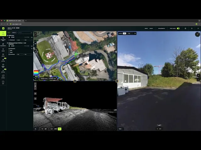
Multi-window split-screen for simultaneous 2D and 3D visualization
Simple subscription model based on data storage rather than token calculations
Direct upload and sharing workflow eliminating need to create custom deliverables
Results
99 active users across various teams now access data independently
Project managers, design teams and non-technical users can utilize drone data for cross sections and measurements without survey team involvement
Eliminating unpredictable costs with straightforward storage-based pricing
No need to create deliverables for progress updates—everyone accesses the latest data fast

When sharing becomes harder than surveying
QTS Group’s work spans the full range of rail infrastructure engineering, from earthworks and drainage to walkways and access stairways and much more. Projects vary dramatically in scale and complexity.
For Paul Brazill, Survey Technical Manager accountable for drone operations at QTS Group, the challenge wasn’t capturing data. It was getting it into the right hands.
“Before using AVAG, it was quite difficult because we had no way of sharing all the drone data,” explains Paul, a land surveyor by trade and Accountable manager/Remote pilot who has led and grown the company’s drone operations over the past seven years.
QTS Group is a multi-disciplinary railway construction company operating across the entire UK rail network, with approximately 800 staff and a specialized survey division. Their drone team is deliberately lean—just four pilots who handle all drone operations nationwide, due to grow over the coming years—but their work supports a much larger ecosystem of designers, engineers, and project managers.
The problem was that each dataset lived in isolation, accessible only through specialized survey software that most of their colleagues didn’t have or couldn’t use effectively.
“We had to create files for everyone. We’d publish things as PDFs, send snapshots of orthomosaics or CAD drawings,” Paul recalls. “There was a lot of back and forth.”
A market flooded with single-purpose tools
When Brazill began evaluating platforms to solve the sharing problem, he found a crowded marketplace, but not much that actually worked.
“I tried quite a few different options out there. But there was no one platform that had so many parts that you could use,” he says. “They all promised to do something in particular, but they only really have one thing that they can do.”
Most platforms Paul tested fell into one of two camps: they either focused narrowly on a single function, or they used complex token-based pricing systems that made it difficult to predict costs across multiple projects.
“On other platforms, they use a lot of token-based systems where you have to calculate how many tokens you need for each project,” Paul explains. “With AVAG, we have an actual data size that we can work off of. That shines for me because it’s quite simple.”
The subscription-based model meant one less administrative burden for a small team stretched across the country.
Testing what works in practice
The decision to adopt AVAG followed a straightforward trial period. QTS Group started with 200 GB of storage, enough to validate whether the platform could handle their workflow and whether their teams would actually use it.
“That trial was enough for us to realize that there was quite a lot of potential,” says Brazill. “And to be honest with you, you do exactly what was advertised.”
Within months of the trial, QTS Group purchased an enterprise solution. Today, they have 99 active users, 117 datasets published, and projects visible across the UK.
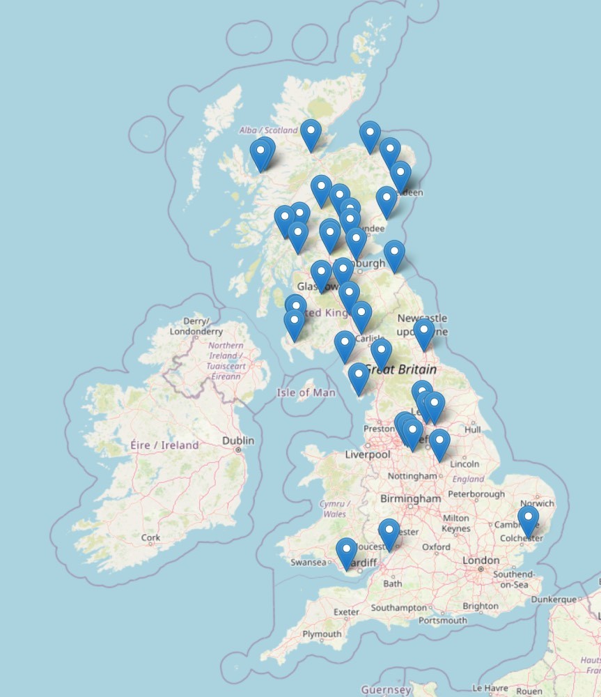
Objects and sites where QTS Group conducts drone mapping and works with the data directly in AVAG.
What convinced Paul was also the responsive support team. “The support we had from you guys has been top level. Even when the subscription overran and we didn’t realize, you were like, ‘Yeah, it’s fine. We’ll get to that later.’ If a service ends unexpectedly, that’s when you panic. But you guys are open and ready to help us out.”
“For me, the most valuable aspect of AVAG is that it encourages wider use of drones by making the data genuinely usable for designers, project managers and non-technical users, not just survey specialists.”

Paul Brazill
Survey Technical Manager, QTS Group
How drones transformed the entire survey department
“Our whole survey department has changed since taking on drone surveying,” Paul explains. “We now utilize the drone over traditional survey techniques.”
For Paul and his survey team, AVAG functions primarily as a distribution platform. “As a survey department, it’s all about uploading the data and sharing it correctly. That’s the main focus for us,” Paul explains. “But the usability for the rest of the company is what we were looking for.”
The impact has been most visible in how design team’s work. Before AVAG, designers would request specific deliverables, like cross sections, topographic data, measurements, each requiring manual work from the survey team.
“Now with AVAG, we actually have less interaction with the design team because they have all this information on hand, and we can overlay CAD drawings and designs,” says Brazill. “We’re collaborating more, but more in a digital aspect than face-to-face.”
The shift has been tangible: design teams can now pull their own cross sections, extract topographic data, and reference current site conditions without waiting for custom survey deliverables.
“People can get a lot more out of the datasets than others have physically put effort into. It’s taken a lot away from the survey team in that respect,” Paul notes.
Reducing the meeting overhead
One of the most practical benefits has been the reduction in coordination overhead. Previously, every dataset required explanation and walkthroughs.
“Viewing the data themselves without having meetings to go over the data has been vastly reduced,” Paul explains. “Having hands-on with the data, the teams can see the direct benefit rather than hearing what we can do with the data.”
This shift from showing to enabling has freed up time for the survey team while simultaneously giving other teams faster access to the information they need.
“Before AVAG, drone outputs existed but weren’t truly accessible to the teams that needed them; after AVAG, they become a shared, practical decision-making tool.”
Paul Brazill
Survey Technical Manager, QTS Group
Visualizing change: The before-and-after tool
While many construction companies use platforms like AVAG for progress tracking against design plans, QTS Group has found particular value in a different application.
“For us, it’s not about progress mapping, we currently use it as a before-and-after tool, which shows the vast changes made on site,” Paul explains. “However, this will evolve through time”
The split-screen visualization capabilities make this particularly effective. Teams can overlay Orthomosaics from different time periods using opacity controls to see exactly what has changed, or lock multiple windows to see side by side views.
Extending access to clients
The platform’s value extends beyond internal teams.
“The clients can actually look at their as-built information. Before, we would publish things as PDFs and send them snapshots of orthomosaics or CAD drawings,” Paul explains. “We don’t always need to produce those drawings anymore. We can just upload everything to AVAG.”
This direct access means project managers, site managers, designers and all other users can review progress and site conditions on their own schedule, reducing the volume of formal deliverables and status update requests.
Combining data sources
QTS Group doesn’t rely solely on drone data. Their workflow integrates multiple capture methods:
Drone photogrammetry for terrain, inspection and site overviews
RoView Confined Space Surveying for drainage networks and culverts
Terrestrial photogrammetry methods for structures and confined spaces
Traditional laser scanning for detailed structural work
Ground control points established with GPS and total stations
“All the datasets can be put together,” Paul explains. The team hasn’t yet experimented with importing laser scanning data into AVAG, but they’re planning to test it this year.
They’re also exploring 360-degree imagery integration, having already invested in 360 camera imagery across the rail network. “Pairing the data with the drone data would be perfect.”
Looking ahead: Expanding into inspections
As QTS Group expands its drone department in 2026, Paul expects their needs to grow. But the team is also exploring new applications for the platform.
“The plan is to utilize AVAG for inspections. We are now evaluating its suitability for large-scale inspection data hosting and expect our use of the platform to evolve over time,” Paul explains.
The team is also planning to implement DJI Dock for automated monitoring, with processing handled through the AVAG cloud platform.
Despite operating as a four-person drone team, QTS Group maintains a comprehensive training approach: “Every person that does any of the drone surveys has to know every in and out. It’s not a case of ‘they have to do it’, it’s more for personal growth. It’s another thing they can learn and add to their knowledge base.”
Making drone data genuinely usable
This philosophy extends to their technology choices. After evaluating numerous platforms, Paul’s advice to other construction companies is pragmatic: “Try all platforms and see what works best for you. But with AVAG, having so many great features, it works for us, the cost is low, and it’s quite easy to use. You get a lot out of it, and the team is always helpful and there for support.”
AVAG highlights
99 active users across survey, design, and project management
117 datasets shared across UK-wide rail infrastructure projects
Simple pricing based on storage capacity instead of complex token calculations
Multi-source integration supporting drone, laser scanning, mobile mapping, and 360° imagery
“Paul and his team have changed how their entire organization accesses and uses drone data. That's one of the problems we built AVAG to solve: making survey data accessible to everyone who needs it, not just the specialists who created it.”

Miroslav Staubr
CEO, AVAG Pro
Application
Make decisions in hours instead of weeks
Turn drone data into action with AVAG. Capture, process, and visualize your site faster than ever.