Features
How it works
Upload drone, scanner, and 360° camera data and get orthophotos, elevation models, point clouds, and invoice-ready volume reports back the same day.
Upload anything, process your way
Bring in raw JPG photos with GPS, LandXML design files, 360° panoramic tours, or outputs already processed in other tools.
Every upload gives you a choice: free Automated processing (no GCPs, results ready in around 35 minutes for a 250-photo dataset) or Expert processing, where AVAG's photogrammetry team applies GCPs and verifies accuracy before delivery.
www.avagpro.com
www.avagpro.com

See every layer, every date, side by side
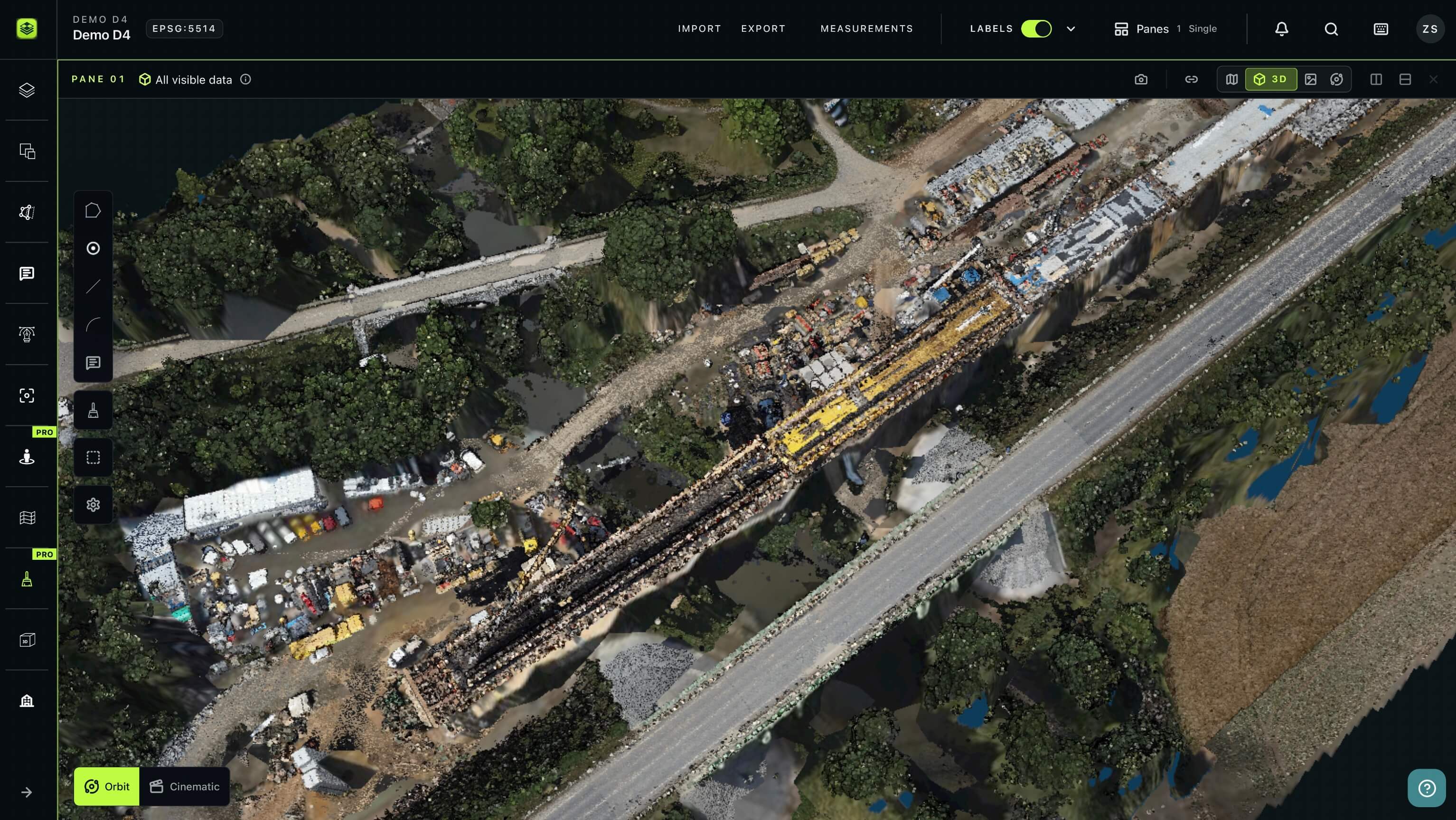
Every dataset unpacks into orthophoto, DSM, slope, and point cloud sublayers, stacked chronologically so the newest flight sits on top.
Open several panes at once to compare two dates, check the 2D map against the 3D point cloud, or line up a design surface against the latest survey, each window independent, each one showing whatever view mode the comparison calls for.
Measure what matters
Draw a polygon and get a volume calculation against a triangulated base, a design surface, or a second survey date, with a cut/fill map generated in the same step.
Draw a line for an elevation profile or an automatic series of cross-sections along a corridor. Every measurement exports to a PDF report or to DXF, GeoJSON, Shapefile, or CSV for other tools your team uses.
www.avagpro.com

Step by step
Upload your photos, design files, or pre-processed outputs.
Process. Automated jobs typically finish in under an hour; Expert jobs average 9 hours.
Visualize. Your new layer lands on the map with orthophoto, DSM, slope, and point cloud ready to view in 2D or 3D.
Measure. Draw polygons for volumes and cut/fill, lines for profiles and cross-sections, points for instant elevation reads.
Share. Export a PDF or just invite stakeholders into the project directly.
Every format, every workflow, one platform
No matter how your data comes in or where it needs to go, AVAG keeps it in one place, ready to import, analyze, and share.
Import and export in every format your team uses
Move data in and out of AVAG without ever stopping to convert a file.
Process raw files or import processed outputs
Export PDF volume reports, ready to send to clients
Export measurements in formats your team needs
Overlay designs and maps on real site data
Bring your plans into the same view as your survey.
Overlay CAD drawings and 3D design models on your survey data
Compare designs against real site conditions
Bring in background maps for any region
Measure, compare, and analyze in one workspace
Go from raw data to invoice-ready numbers without leaving the map.
Calculate volumes, single-layer or between two dates
Generate terrain profiles and automatic cross-sections
Compare up to 4 windows side by side
Share results with your team and clients instantly
Give everyone who needs access exactly what they need, the moment it's ready.
Share layers, drawings, and photos in one place
Combine 360° tours and high-res photos into the same view
Control access at the project level
Benefits
Why teams choose AVAG
Unlimited users on every plan
No per-seat fees. Invite your whole crew, your subcontractors, and your clients
EU-based data hosting
With six interface languages and support for any coordinate system
A real choice in processing
Free automated results for fast monitoring, or expert human-verified accuracy when the numbers drive billing
Autosave
Multi-source ingestion
Drone, scanner, 360° camera, and CAD design files in one project
What others have achieved
STRABAG processed 10.5 km of highway into invoice-ready earthwork documentation in hours, with centimeter accuracy
QTS Group's 4-person drone team now supports 99 active users across 800 staff, with instant access to more than 117 datasets nationwide
EUROVIA CZ achieved full ROI in 3 months, with real-time progress tracking and precise volume calculations
M-SILNICE cut surveying time from days to minutes on a major highway project
Geospatial data platform
See it in action
Explore how you can turns raw footage into accurate visualizations, volume calculations, and progress reports:
Features
Frequently asked questions
What file formats can I upload to AVAG?
You can upload raw JPG/JPEG photos for processing, or already-processed outputs like GeoTIFF (.tif/.tiff) for orthophotos and DSMs, LAS/LAZ for point clouds, and mesh files (.zip with .obj/.mtl/.jpg). You don't need to provide all of them, only the outputs you have.
Can I import designs from CAD software?
Yes. AVAG accepts LandXML design surfaces and DXF drawings, so you can compare a design directly against your survey data for cut/fill and volume calculations.
Can I import data from other software?
Yes. AVAG supports importing data from photogrammetry software such as Pix4D, Agisoft, 3DSurvey, and DroneDeploy. Supported formats for photogrammetric data import include TIFF, LAS, and LAZ. For mesh data, AVAG supports a ZIP package that must contain JPG, OBJ, and MTL files.
Does AVAG support 360° camera imports?
Yes. AVAG supports pre-stitched 360° tours from a range of devices, including FARO, GeoSLAM, Mosaic X, and CHC RS10, along with the metadata file each capture requires. For map visualization, this includes formats such as CAD drawings, WMS services, 3D models, DXF, TXT, CSV, PDF, Shapefile, and others. For importing photogrammetric data, AVAG supports TIFF, LAS, and LAZ files, as well as mesh ZIP files containing JPG, OBJ, and MTL files. In addition, you can upload high-resolution grid photos, 360° panoramic images, and more.
How many people can use AVAG on my account?
Unlimited. Every plan supports unlimited users at no per-seat cost, with access rights set at the project, object, or layer level.
How does AVAG calculate volumes?
Automated processing is fully automatic, free, and fast (no GCPs). Draw a polygon and AVAG calculates volume against a single triangulated layer or between two layers (e.g., two survey dates, or a design vs. a survey), generating a cut/fill map in the same step.
Can I generate terrain profiles or cross-sections?
Automated processing is usually complete in minutes, but it depends on how large your dataset is. For example, 250 photos without GCPs take 35 minutes from upload to results. Yes. Draw a line for a terrain profile across any layer, including designs, or use the automatic cross-section generator to create a series of sections along a corridor.
Is it possible to share data with colleagues or external partners?
Yes. You can invite unlimited users and assign access rights to projects, layers, objects, or datasets. Users with access to an object can also share measurements and calculations directly from the map by simply creating a folder, moving the relevant items there, and sharing it.
How does storage capacity work in AVAG?
Your storage capacity includes everything stored in AVAG, such as uploaded photos, processed outputs, documents, and imported files. Example: If you upload photos with a size of 1 GB and processing generates outputs of 1.5 GB, your total used storage will be 2.5 GB. To save storage, you can delete the original photos after processing and keep only the processed outputs.
Is my work saved automatically?
Yes. AVAG autosaves as you work, so there's nothing to manually save or risk losing mid-session.
Which languages are supported?
AVAG is available in six languages: English (EN), Czech (CZ), German (DE), Polish (PL), Portuguese (PT), and Spanish (ES), ensuring accessibility for a broad user base worldwide.